History of Wat's Dyke
The history of Wat's Dyke
Although there is no certainty as to who Wat was, with some believing he was a king of Mercia and others saying that he did not exist at all, and with the name Wat being a personal name during the Anglo-Saxon period, and even that the word could also mean wet or rough, the only certainty is that the dyke exists.
When the dyke was constructed is again another mystery. Until relatively recently, many historians had thought the dyke was an eighth century Mercian near-contemporary of the more famous Offa’s Dyke, that runs parallel and to the west of Wat’s Dyke are now having to re-think their theories. Others though suspected it was earlier and that it pre-dated Offa’s Dyke and attributed its construction to King Offa’s predecessor, Aethelbald who lived between 716 and 757AD.
The most accurate indication yet about when it was built though, came as a result of radiocarbon dating of charcoal found with shards of Romano-British pottery following an archaeological excavation of a section of the dyke at Maes y Clawdd near Oswestry carried out at Queen’s University, Belfast, which dated its construction at between 411 and 561AD.
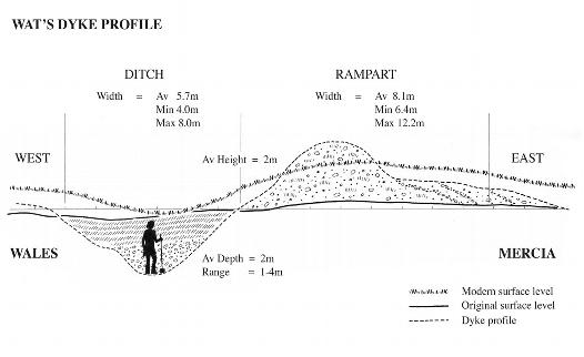
The mystery still remains though as to who actually constructed the dyke and whether it was a mutually agreed boundary or a military fortification in a disputed area as its bank and ditch construction suggests. A Shropshire County Council archaeological service report however says that the radiocarbon date for the earthwork suggests that the people who constructed the dyke were not the 8th century King Offa or Aethelbald.
Instead, the report places its construction at some time in the 5th or early 6th century, the period that begins with the departure of the Roman military and ends with the area’s incorporation into Mercia. The radiocarbon dating, centred on 446AD at a time when the area may have formed part of an independent British kingdom whose capital was at Wroxeter, thus pre-dating Offa’s Dyke by some 300 years.
The report also goes on to say that the dyke should therefore be regarded as being contemporary with that other great 5th century linear earthwork; the Wiltshire Wansdyke and should be considered as an achievement of the post-Roman kingdom of the northern Cornovi, rather than the work of 7th or 8th century Mercia.
As further evidence of this theory, the report also says that there is strong evidence of a structured and ordered society in that part of the world in the 5th century, and that it was perfectly feasible that such a kingdom would have had the resources to undertake the construction of a massive earthwork on the scale of Wat’s Dyke to mark its western boundary.
This brief history of Wat’s Dyke is based on information contained in the following:
‘Wat’s Dyke’; a brochure produced by Margaret Worthington for the Beaufort Park Hotel & Conference Centre, Alltami near Mold; and a report published in the Daily Post on 16 August 1999 based on a Shropshire County Council archaeological service report.